
Mount Eagle St. Croix Hike: Little Effort. Big Reward.
It was Christmas morning, and my husband and I had just enjoyed a delicious homemade breakfast of an egg biscuit, crispy hash browns, a cinnamon bun, and a glass of sparkling wine. Before settling in for a relaxing afternoon by the pool, I wanted to squeeze in some exercise. The Mount Eagle hike in St. Croix turned out to be the ideal choice. An invigorating workout paired with breathtaking views! Finding the trailhead can be a bit tricky, so keep reading for tips on getting there and what to expect along the way.
* Some of the links in this post contain affiliate links. If you make a purchase through these links, we may receive a small commission at no extra cost to you. All recommendations are from first-hand experience that I feel will deliver value to you! Thank you for your continued support.
FOLLOW & SHARE WITH A FRIEND!


Quick Overview of Hike
- Hiking time: 1 hr. 10 min. (40 minutes up and 30 minutes back)
- Difficulty: easy
Mount Eagle is the highest mountain in St. Croix. The trail was wide, easy to follow, and offered a fair amount of shade. It had recently rained when we went, so there were a few muddy sections. Wear hiking shoes. I love my trail runners for this kind of hike.
We incorporated this hike towards the end of our 8 day St Croix itinerary.
How to Find the Trailhead

Map of Mount Eagle St. Croix hike
1. Use Rowdy Joe’s as your starting point. If you are at Rowdy Joe’s, turn right on Hwy 73.
2. Eventually, Hwy 73 will T-bone into Scenic Rt 78. Turn right on Scenic Rt 78 (more of a gravel road now, not as well paved)
** Continue to refer to the map above for reference.

Turn right on Scenic Rt 78
3. There will be another junction point where you choose to stay left on the main road or go up another road to the right.
Stay left.

Hi, I’m Nichole. The discerning traveler, wine lover, and adventure seeker behind Enriching Pursuits.
On this website, you'll find expert insights, honest reviews, and carefully curated experiences worth your time.
I specialize in uncovering the best outdoor adventures (especially snorkeling!), incredible foodie experiences, and boutique stays for travelers who appreciate the details as much as I do.

Want more?
Stick around, explore more, and the next time you plan a trip, just Google Enriching Pursuits!
Is this your travel style?
Then subscribe below to receive my latest updates on:
→ Boutique Stays — Hotels loaded with charm & warm service
→ Sip & Savor — Wine getaways with must-visit wineries and eats
→ Outdoor Adventures — Epic snorkeling, hikes, and bike trails
→ Foodie Finds — From hidden gems to Michelin-star dining
→ Smart Travel Gear — Product reviews that make travel better
→ Nichole Pro Tips — Save smart, splurge wisely!

Stay left at the next junction
4. The road now is basically a 1-way road.
I held my breath during this part that no one else would be coming from the opposite direction.

One way road to Mt. Eagle hike in St. Croix
5. Eventually you will reach a wide circular grassy area to park your car. When we went, we were the only ones there.
6. After you park the car up on the left, walk on the road to the right.
7. Shortly after walking along the road/grassy trail, you will see the trail veer off to the right. Hike right. This is the start of the Mount Eagle trail.

Park on the left. Trail starts on the right.

At the next junctional point, hike to the right.
Step-By-Step Hiking Experience
When we went, it had recently rained. The start of the trail was a little muddy. Wear good shoes!

Muddy trail on Mount Eagle St. Croix hike

Lots of sections of shade on the Mount Eagle St. Croix hike
Along our hike, we came across this unusual-looking fruit that I had to look up later.
It is called soursop. It has a green prickly outside and a creamy white interior that supposedly tastes like a cross between a pineapple, mango, and a little citrus. Others state they can pick up flavors of apple and banana.
I have never tasted it but can’t wait to try it. People enjoy it raw (don’t eat the seeds though), or have it in tropical drinks, smoothies, and juices.

We came across soursop (green prickly fruit) on the Mt. Eagle hike
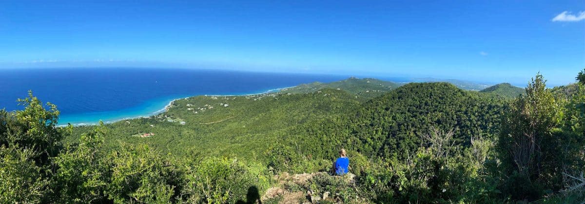
30-40 minutes later you will come to a large rocky outcropping to soak in all those views.
Little effort, big reward!

Panoramic views from Mt Eagle in St Croix

On the rocky outcropping at Mt. Eagle in St Croix
Final Thoughts
We stayed in Cane Bay (highly recommend!) during our St Croix vacation, so it only took us about 20 minutes to get to the trailhead.
This was an easy hike to get some great exercise and have a big payoff at the end by taking in those spectacular panoramic views. You can get a quick hike in the morning and have plenty of time in the afternoon to do another activity. If you are looking for more activities, check out my Top 13 Things to Do in St Croix.
If you love hiking, another great hike to check out in St Croix is Jack & Isaac Bay.
Related Content

St. John vs St. Croix: Battle of the Islands
The U.S. Virgin Islands is home to three stunning...

Where to Stay in St. Croix: Best Hotels & Rentals by Neighborhood
So, you’ve picked St. Croix for your next Caribbean...

8 Day St. Croix Itinerary: Where to Stay and What to Do
When you think of the U.S. Virgin Islands, most people...

Best Buck Island Tour: Review of Llewellyn’s Charter
If you’re planning a trip to St. Croix, you’ll quickly...
REACH OUT, FOLLOW, OR SHARE THIS POST WITH A FRIEND!
Questions about the Mt. Eagle hike?
Let me know in the comments below!
I just wanted to let you know that we were in St. Croix July 2024 and tried to get to the trailhead to this hike using your maps and instructions and it was not safe to do so. We asked several locals and they said there was a landslide at Mount Eagle and it is no longer safe to hike.
Thank you for providing the update.
We did the hike in December 2020 when it was an easy wide trail to follow.
I am sorry to hear that’s changed because it really was a beautiful hike with great views.
I’ll continue to keep these comments open in case something changes and additional safety measures are put in place.
Thanks again for sharing.
Thanks for this page! Did the hike this AM, and your directions to the trailhead were crucial.
I parked at where Valley View Road tees into Scenic Road, and hiked from there (wasn’t sure the rental could make that uphill; felt sketchy on VV, TBH). The circular parking area is still there, but wildly overgrown, and it feels like you’re walking into the woods as opposed to finding a trailhead – but it’s there. 🙂
Your info was great; thanks again! And maybe the track below can help, too (I was going to upload the GPX file, but it doesn’t look like I can)
Thank you for sharing your experience, and I’m so glad the directions helped you find the trailhead!
When we visited, the parking and trail were clearly marked, but it sounds like things may have changed. A few readers have also mentioned safety concerns, so I’d suggest checking with locals before setting out and making sure the hike is still considered safe.
Really appreciate you adding these helpful updates for future readers!